Satellite [UK:*/ˈsætəlaɪt/US:/ˈsætəˌlaɪt/ ,(sat′l īt′)]
sat•el•lite /ˈsætəˌlaɪt/ n. sat•el•lite /ˈsætəˌlaɪt/ n.
[countable]1. Astronomy – a natural body in space, as a moon, that revolves around a planet:one of the satellites of Jupiter.
2. Aerospace – a device launched into orbit around the earth, another planet, the sun, etc.: a satellite that takes regular photographs of the Earth.
3. Government – a country under the control or influence of another: one of America’s satellites in Africa.
Example of usage in the energy sector
Satellites are used to acquire images of the Earth at different spatial resolutions. For the solar sector, images from satellites can be used to estimate the irradiance at ground level.
In pop culture
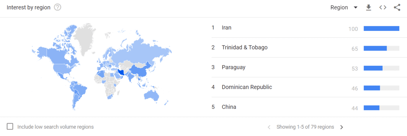
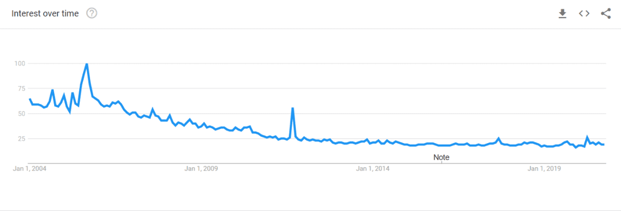
In Google trend, worldwide search “artificial satellite” from 2004 reports Iran as the most interested region.

The interest over time is quite declining.

Related topics are:
- India Meteorological Department – Govern
- Al Yah Satellite Communications – Company
- Google Street View – topic
- Starlink- topic
- Elon Musk – CEO of SpaceX
Related queries are:
- google earth
- imd satellite
- imd
- google maps satellite
- india satellite image
Did you know?
Historically, there are several satellite missions provided by governmental entities such as NASA, ESA, ASI. Recently, many private companies are filling the gap between research-based satellites and end-users necessities. Several private satellites are very small and are called CubeSats, because they are made up of multiples of 10 cm × 10 cm × 10 cm cubic units (for comparison, a soccer ball is about 22 cm in diameter)! More than 1.200 CubeSats have been launched as of January 2020.
Etymologycal origin
Satellite comes from the Latin satellit- (stem of satelles) attendant, member of bodyguard or retinue (possibly from Etruscan origin).
Source: WordReference.com
At i-EM
We perform data analysis using satellite-based observations: for example, the performance KPI calculation for your plant using ground measurement data and satellite-based data. Satellite-based data are especially useful in case of missing data or in general when data measured onsite are not available or not reliable.
Since the solar measurements greatly influence the final KPI value, it is crucial to quantify accuracy and understand the specific characteristics of the instrument used to measure them.
For the curious costumer
At i-EM S.r.l. we have what you need (we hope!)… Try us!
Author
Fabrizio Ruffini, PhD
Senior Data Scientist at i-EM


